|
Brenda J. Pritt Executive Director
Randolph County Convention & Visitors Bureau
1035 N. Randolph Avenue, Elkins, WV 26241
-
- Ofc: 304-636-2780 Fax: 304-636-2780
E-Mail:
________________
-
Gordon Blackley
Cat Cole
Chelley Depp
Julia Elbon
Judy Guye
Jimmy Hammond
Jill Jeffries
Kathleen Lavengood
Dan Noel
Diane Noel
Brenda Pritt
Tom Reagan
Barbara Story
Douglas Tuning
Gary Wileman
Stan Williams
|
 - State Highway 20
- Hacker Valley, West Virginia, 26222
- (304)-493-6353
- https://www.hollyriver.com/
- index.html
- Open all year, 6AM to 10 PM
- Cost: Free
-
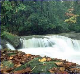
Holly River is the second largest park in the West Virginia park system with a total of 8,101 acres. Nestled in a narrow valley, the park is surrounded by heavily forested mountains some reaching heights of over 2,800 feet. Through hiking on the many trails, the park offers a way to get acquainted with the flora and fauna of the region. There are trails to two waterfalls, Tecumseh and Tenskwatawa, named for two legendary Indian chiefs of the area. A hike to Potato Knob delivers a commanding view at 2,480 feet.
- Directions:
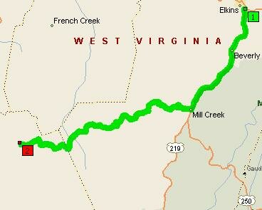
- Go South-West from Elkins on US-219 [S Randolph Ave] for 16.4 miles
Turn RIGHT (West) onto CR-46 [Mill St] for .6 miles
Bear RIGHT (North-West) onto CR-46 [Helvetia-Adolph Rd] for .2 miles
Turn LEFT (South) onto CR-42 [High Germany Rd] for 5.6 miles
Turn LEFT (West) onto CR-46 [Helvetia-Adolph Rd] for 12.2 miles
Turn LEFT (South-West) onto CR-45 [Pickens-Helvetia] for .2 miles
Turn RIGHT (North) onto CR-45 [Zambaugh] for 1.5 miles
Keep STRAIGHT onto CR-52 [Silica Rd] for 3.7 miles
Bear RIGHT (West) onto CR-52 [Pleasant Hill Church Rd] for .1 miles
Road name changes to CR-10 [Goshen] for .9 miles
Bear LEFT (South-West) onto CR-10 [Baili Ridge Rd] for 2.9 miles
Bear LEFT (West) onto CR-10 [Park Rd] for 3.6 miles
Turn RIGHT to stay on CR-10 [Park Rd] for .8 miles
|